


The hidden radar watching Formby’s coastline is moving on today
- Mar 21
- 2 min read

Most people walking along Formby beach over the past few weeks may not have realised they were being watched… but not in the way you might think.
Today marks the final day of a specialist coastal radar deployment on the dunes between Cabin Hill and Lifeboat Road, quietly monitoring everything from waves and tides to the movement of sand beneath our feet.


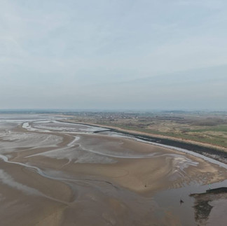


The equipment, operated as part of North West coastal monitoring work, has been collecting data 24 hours a day, building up a detailed picture of how Formby’s coastline is constantly changing.
📡 The radar is a line of sight system that can scan across a six kilometre area, tracking:
• Beach shape and levels
• Water depth near the shore
• Wave patterns
• Currents and tidal movement
Unlike traditional surveys, this technology works continuously in all conditions, giving a far more complete understanding of what is happening along the coast.
The information gathered helps experts monitor erosion, understand how sandbanks shift, and improve coastal management decisions that protect places like Formby’s dunes and surrounding areas.

The team behind the project thanked National Trust Formby for allowing the temporary setup, which has been positioned high on the dunes to maximise its reach.
From here, the equipment will now be moved to Squires Gate in Blackpool, where it will focus on a particularly important stretch of coastline where hard sea defences meet natural sand dunes.
There is already a longer term five year radar installation operating at Granny’s Bay, showing just how important this type of monitoring has become.

While many of us simply enjoy the beach for walks, fresh air, and stunning views, there is a huge amount of science happening in the background to understand and protect it for the future.
And as these images show, Formby’s coastline is as dramatic as it is ever changing.


.jpg)


Comments